Why Agricultural Drones Are Changing the Way We Manage Crops
The Shift Toward Smarter Farming
I have been involved in arable farming for over a dozen years, and I can tell you that nothing has altered my weekly routine quite like the arrival of agricultural drones. A few seasons ago, if I wanted to check how a field of winter wheat was doing after a dry spell, I had to pull on boots, walk the tramlines, and guess at the variability I could not see. Today, I watch a live feed from a DJI Agras platform while standing at the farm gate, and I make decisions based on data rather than instinct. The difference is not subtle. It is the difference between treating every square metre of a field the same and treating it exactly as it needs.
This is not about gadgets for the sake of gadgets. It is about precision agriculture finally becoming practical for ordinary farms. The technology has matured enough that a farmer in the Cotswolds or the Fens can justify the cost by the savings in agrochemicals, fertiliser, and time. And the core of that shift is the agricultural drone.
How Drones Fit Into a Working Farm
When people hear the term "drone spraying", they often picture a noisy quadcopter buzzing over a vineyard in California. That image is accurate as far as it goes, but it misses the scale of what is happening in broadacre farming. Modern platforms such as the DJI Agras T40 or the XAG P100 can carry tanks of 30 litres or more, and they spread seed or spray crop protection products at rates that match ground rigs over smaller, awkward fields. I have seen a neighbour use one to apply a fungicide to a sloping barley field that a tractor simply could not enter without compacting the soil. The drone flew the job in 40 minutes. A tractor would have taken three hours and left ruts.
That is where the real value lies. Not in replacing all ground equipment, but in doing the jobs that ground equipment does badly. Steep ground, wet patches, headlands, and late-season access are all situations where a drone earns its keep. And because the drone flies low and slow, the spray goes exactly where it is aimed. Drift is minimal, which matters when you are working near watercourses or neighbouring organic land.
Beyond Spraying: Seed Spreading and More
One of the quieter revolutions has been in seed spreading. Cover crops, for example, are notoriously hard to establish in a standing cash crop. You can broadcast seed from a tractor, but much of it lands on the canopy and never reaches the soil. A drone flying just above the crop canopy can place the seed where it needs to go. I have used this technique to undersow ryegrass into maize, and the establishment was better than anything I had achieved with a conventional spinner. The same principle applies to overseeding pastures or establishing catch crops after harvest. The accuracy of GPS guidance means you can map exactly where the seed has landed and adjust your rates next time.
Field mapping itself has become a routine first step. Before I fly a spraying or spreading job, I send a drone over the field with multispectral sensors. Those sensors capture reflected light in bands that the human eye cannot see, and the resulting images show me exactly which parts of the crop are stressed, where the weeds are emerging, and where the nitrogen levels are falling off. That information feeds into variable rate application maps. Instead of applying a blanket rate of fertiliser across the whole field, I can give each zone what it actually needs. The savings in fertiliser alone can be 20 to 30 percent on some fields, and the crop health monitoring data tells me whether those savings come with a yield penalty. Usually, they do not. The crop actually does better because it gets what it needs when it needs it.
The Hardware Behind the Hype
There are two main families of agricultural drone platforms right now. The multicopter designs, like the DJI Agras and the XAG models, are the workhorses for spraying and spreading. They are heavy lifters with big payloads, and they operate close to the ground. Then there are fixed-wing platforms such as the eBee from SenseFly. These are primarily for aerial imaging and crop health monitoring over large areas. An eBee can map a thousand hectares in a single flight, carrying multispectral sensors that generate orthomosaic maps with centimetre-level resolution. That data is invaluable for drawing up variable rate application plans and for tracking yield data across seasons.
Both types rely on the same core technologies: GPS guidance for precise flight paths, remote sensing for data capture, and increasingly sophisticated software for turning that data into actionable plans. The hardware has become reliable enough that I rarely worry about a mid-flight failure. The batteries last long enough to cover most fields in a single session, and the charging infrastructure on a farm is straightforward. A generator in the back of a pickup can keep a fleet of batteries topped up all day.
Practical Considerations and Trade-Offs
I would not want to give the impression that agricultural drones solve every problem. They have limitations. Payload is the most obvious one. A drone can carry only so much liquid or seed, which means you need to land, refill, and take off again multiple times per field. That is fine for a 10-hectare block but becomes tedious on larger fields unless you have a team with multiple drones and a dedicated refill station. The trade-off is that you can treat fields that a tractor cannot reach at all, and you avoid soil compaction entirely. For many farmers, that trade-off is worth the extra logistics.
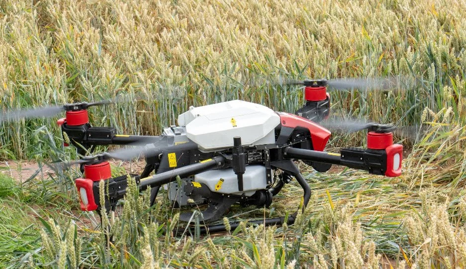
Another practical point is the weather. Drones do not fly well in strong wind or heavy rain. A gusty afternoon can ground a spraying operation just as surely as it can stop a tractor. But because drones fly low, they can often work in conditions that would make a light aircraft abort. I have flown spray jobs in winds that would have kept a manned helicopter on the ground, simply because the drone stays inside the boundary layer near the crop canopy where the wind is weaker.
Data That Pays for Itself
The most underestimated benefit of agricultural drones is the data they generate. A single flight with multispectral sensors can reveal patterns of weed infestation, nutrient deficiency, or drainage issues that would take hours to find on foot. Over a season, the aerial imaging builds a record that helps you make better decisions about crop rotation, variety selection, and input timing. I have seen farmers cut their plant protection costs by a quarter simply because they stopped spraying whole fields and started spot-treating the areas that actually needed it.
Variable rate application is the mechanism that turns that data into savings. The drone itself can apply the variable rates if it is equipped with the right software, or you can export the maps to a tractor's controller. Either way, the result is the same: less waste, better crop health, and a smaller environmental footprint. And when you are dealing with expensive inputs like liquid fertiliser or specialist agrochemicals, those savings add up fast.
Where the Industry Is Headed
The pace of change in agricultural drones is still accelerating. The latest models from DJI and XAG feature terrain-following radar, obstacle avoidance, and automated flight planning that requires almost no piloting skill. The software side is catching up too. It is now routine to import a field boundary, generate a flight path, apply a variable rate map, and execute the entire job without touching a remote control beyond the initial launch. The next few years will bring larger batteries, longer flight times, and probably swarms of smaller drones working together over big fields.
I also expect to see more integration between drone data and farm management software. Already, some platforms can take multispectral images, process them into prescription maps, and send those maps to a drone or a tractor in a single workflow. That kind of seamless pipeline is what will push precision agriculture from a niche interest into a standard practice.
For anyone sitting on the fence about whether to invest in this technology, my advice is to start with a mapping flight. Hire someone to fly a multispectral survey of your biggest field during the growing season. Look at the variation in crop health monitoring data, in the yield data from the combine, and in the soil maps you already have. You will almost certainly see patterns you did not know were there. Then you can decide whether the next step is a spraying drone of your own or a contractor who already owns one. Either way, the data alone often pays for the first season.
Agricultural drones are not a futuristic idea. They are a practical tool that is already changing the way I manage crops, and I see the same thing happening on farms across the country. The key is to treat them as part of a system, not as a standalone trick. Used well, they save money, reduce chemical use, and give you a level of control over your fields that was impossible a decade ago. Used badly, they are just expensive toys. The difference comes down to understanding what they can and cannot do, and that understanding only comes from flying them in real conditions. If you get that part right, there is no going back.
Ends · 05OYSWWM7E